

On the back of our gravel bikes, and in collaboration with Volata y Strava,we discovered one of the most charming, attractive and, for sure, most unknown environments of the peninsula. Who would think that in Murcia are some of the most almost western movie locations? Located to the west of the mountain massif of Sierra Espuñathe Gebas ravines are a characteristic formation of badlands -lands extensively eroded by water and wind due to the lack of vegetation- composed of gullies, ravines and canyons that provide a spectacular appearance reminiscent of a landscape lunar on Earth.

It has a total surface area of 2,271 hectares and is located in the municipalities of Alhama de Murcia and Librilla. Its main interest lies in its geomorphological structure, with an origin that was especially influenced by the water currents of the Algeciras Wadi and its basin on highly erosive terrains. However, in spite of its condition of semi-desert, one of the greatest charms that it contains is a swamp of turquoise waters called the Algeciras reservoir. It will be one of the central elements of these two days of gravel that we spent in the area and in which the group formed byJeroOlga,Sonia eIsraeltogether with David behind the camera lens, we completed two circular routes with a total of 80 kilometers and more than 2000m of elevation gain. accumulated positive elevation gain.
First day: in search of turquoise waters
We start the adventure with an affordable and circular route for all audiences and levels of cycling experience -ideal for first time adventurers. the world of gravel and off-road- which starts from the Hospedería la Mariposa, near Gebas, in the heart of the region of Murcia. This rural lodging will be our base of operations for these two days of relaxed and quiet gravel. They will take care of you in an exceptional way and where you can stay for the night or, why not, a whole weekend in this magical area where the sun and good weather are always guaranteed at all times of the year.
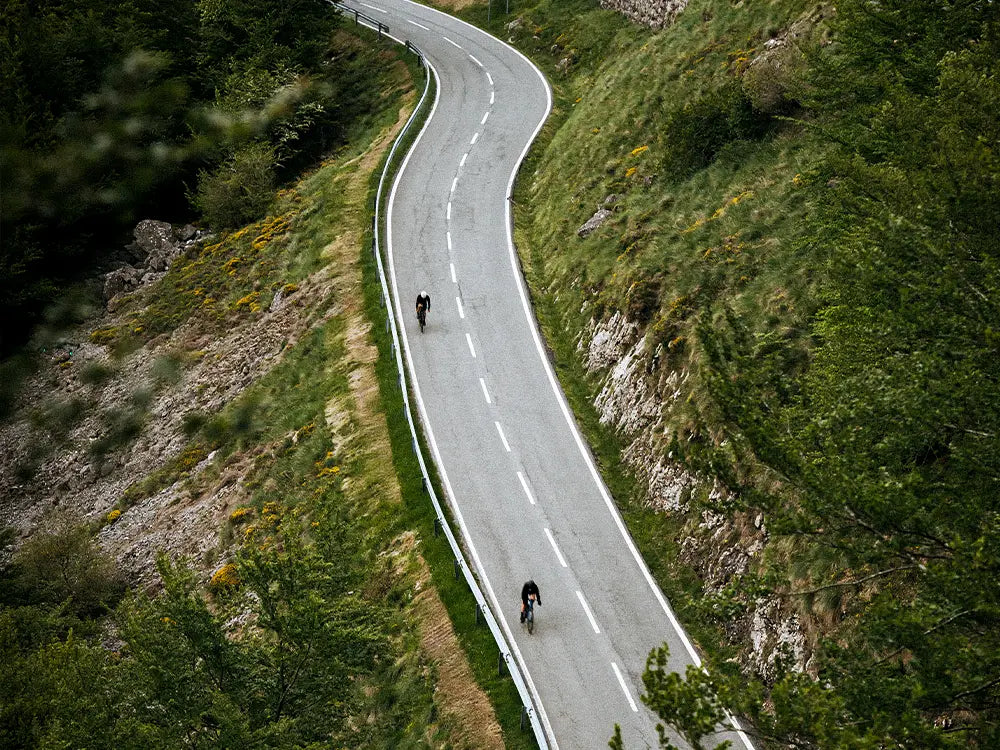
It is a route of just over 36 kilometers that runs mostly on fairly compact tracks and reaches the bowels of this special place. Although it is perfectly cyclable, there are some loose stones that can make us lose control of our bike. It is also suitable for any type of mountain bike or gravel bikeAs in our case, we rode on MMR gravel bikes with Shimano GRX drivetrain in cable and Di2 versions with double chainring 46x30 and 11 speeds (11-34) perfectly suitable for our route. Olga and Sonia were able to put Jero and Israel in trouble on more than one occasion, taking advantage of the winding and winding slopes of the route that, at times, seemed to turn into a maze with no way out.
Shortly after leaving behind the village of Gebas, we head in the direction of Alhama de Murcia by road, going up a port next to El Berro crossroads but following in towards La Muela. From there we head to thePino Gordo trailin the Sierra de la Muela, famous in the local environment and very appreciated by lovers of hiking, which leads to a path of low difficulty and we take the track that runs parallel to the Tajo-Segura water transfer to the right that will take us to the viewpoint of Algeciras where we can enjoy idyllic views of the Algeciras reservoir that will act, from now on, as our point of reference.
The route continues always in a circular direction to the reservoir followinga stretch of downhill track -we must be careful with the slope, which can reach 8%- to then take a wadi up and down in the direction of the water transfer uphill, leaving the ravine on the left. Throughout the journey we will be accompanied by a landscape of arid lands of low altitude and depopulated with vegetation. They are soils of calcareous and clayey materials that are transformed to the rhythm of the wind and water welcome us as we pass, creating unique shapes. The area is completely full of canyons and ravines. This track will lead us to the road that goes from Fuentelibrilla to Librilla, where we will pass the recreation area and take a path on the left that leads to the road to Fuentelibrilla. We cross the village in the direction of El Berro and, at the height of a restaurant, we take the crossing to the left winding through the almond trees and we enter the path that runs along the Loma del Aire to reach, 2 kilometers further on, until we reach the Gebas ViewpointThis is a natural vantage point that was conditioned in 2002 by the General Directorate of Natural Environment, which provides us with truly impressive views, with the turquoise water reservoir on the horizon.

With a capacity of 44.6 Hm3 and built in 1995, is one of the eight protected landscapes in the region of Murcia. and is part of the General Flood Defense Plan of the Segura River Basin, and is also used as storage for the Tajo-Segura water transfer. It is an exceptional place for the sighting of birds that have colonized the area, such as grey herons, gulls, grebes, mallards or stilts, but what really mattered to us was to get to know it on our bikes.
We wanted to get to the deepest part of the ravine, so we continued pedaling among the immense loamy slopes and reached the Water GorgeThis is one of the deepest parts of the ravine and drains, together with the Cabecico Blanco ravine, into the Algeciras wadi, which is the one that feeds the main ravine. At this point, we find a crossroads. After turning right, we reach the jewel of the route and the lowest area: the central part of the Algeciras reservoir or Gebas ravine. Once there we take the opportunity to stop for a while to rest, take "selfies" and regain strength for the return, traveling the same trails in the opposite direction from the outbound to reach the track that leads tothe slope to the cemetery of Gebas -which is the highest point in the area, at 428 m., which makes it another excellent viewpoint to enjoy the landscape- and, in the direction of Alhama, to the Hostelería La Mariposa, where we will rest for the rest of the day.
Second day: stone walls in the Barranco de Leyva ravine.
On this second day of the route we look east, just across the area of the Barrancos de Gebas, to discover another spectacular landscape: the Sierra Espuña. In total, it will be almost 43 km quite affordable but with the ascent to Collado Blanco halfway, with an altitude of 1,220m and with some sections of up to 16% slope, as great difficulty, and with the passage through the Barranco de Leyva, a majestic stone wall very appreciated by the practitioners of climbing, as one of its main attractions.

From the inn, we reach the municipality of El Berro -we can take the local road RM-515 at the exit of Gebas- and the parking area of the recreational area of the Barrancos de Leyva and, from there, we take the Senda de los Dinosaurios, which is very well indicated. Continuing along this path and, almost as soon as we start, we will come across the first mandatory stop: a wooden suspension bridge where it is advisable to get off our bikes and walk across it. From there we can contemplate the fossilized remains of a dinosaur, hence the name of this path.
Approximately 300 meters ahead we will arrive at the main forest track that, practically in a straight line and in a slight but demanding ascent -known asThe Witches-, takes us through the great and splendorous Barranco de Leyva where we can contemplate the impressive and majestic stone walls on our right. As we continue ascending little by little along the main trail. In view of drone the scenery is fabulous, pure and wild.
4 kilometers further on and, after having completed just over 500 meters of accumulated elevation gain, we reach a series of hairpin bends, with two very sharp turns that lead us to the top of Collado Blanco, the highest point of the route. Finally, the landscape opens before us again and we discover a new, different environment, where it is not clear whether we are in Murcia or in the most extensive and spectacular plains of Colorado, in the United States.
It is time to regain strength and, of course, take the relevant photos that immortalize the moment and return to El Berro surrounding the entire perimeter of Sierra Espuña, taking care on the descent, which will be demanding. The 15 km to El Berro allow us to enjoy the diversity of terrain, places, environments, vegetation and nature in its full expression that make this area unique. And the best? To be able to ride it with our bikes.

Texts: Israel Romero
Photos: David Ponce


